Hanoi sets new visions for satellite towns
Satellite urban areas, along with the 'city-within-a-city', remain a core part of the city’s 2045 planning.
Hanoi's updated urban planning for the period 2045 to 2065 reduces the number of satellite urban areas from five to just two: Son Tay, planned as a cultural, historical, and resort town, and Phu Xuyen, which will become an industrial, transportation, and freight transshipment city.
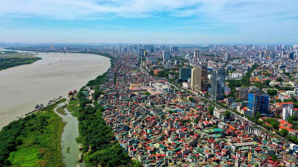
| Hanoi from above. Photo: The Hanoi Times |
The current capital planning until 2030, with a vision to 2050, was approved by the Prime Minister in a decision released in July 2011. It outlined Hanoi's urban structure, which follows the urban cluster model consisting of the central metropolitan area and five satellite urban areas and towns connected by a ring road, integrated with the regional and national transportation networks.
Architect Dao Ngoc Nghiem, Vice Chairman of the Vietnam Association for Urban Planning and Development, suggested this model, successfully implemented in many developed countries, is well suited to Hanoi's characteristics.
However, despite the initial expectations of addressing issues such as population growth, regional integration, and economic development, there has been little progress in the development of these urban areas, namely Hoa Lac, Soc Son, Phu Xuyen, Xuan Mai, and Son Tay, over the past decade.
"This is primarily due to the lack of policy mechanisms, incentives, and private sector involvement in transport infrastructure development," Nghiem said.
Vice Chairman of the Son Tay Town People's Committee, Phung Huy Vinh, said that, despite their best efforts, urban development in Son Tay has been slow. Vinh attributed the main obstacles to the absence of clear criteria and standards for urban development, as well as the lack of resolutions, implementation plans, and policies to attract investment in these urban areas.
In light of these shortcomings in the development of satellite urban areas, Nguyen Trong Ky Anh, Director of the Hanoi Department of Planning and Architecture, explained that the city is now reevaluating and redefining the model and roadmap for satellite urban area development.
Anh noted the goal is to prioritize and focus investment resources based on defined priorities.
For now, the city remains committed to the multi-center urban development model outlined in the government's decision in 2011.
"This model envisions Hanoi as a multi-center area, including the central city and the addition of two "cities within a city" in the north of the Red River [Northern City], the western part of Hanoi [Western City], and satellite urban areas," Anh said.
However, with the merging of satellite urban areas of Xuan Mai and Hoa Lac into Western City, and Soc Son into the Northern City, the number of satellite cities has been reduced to just two: Son Tay and Phu Xuyen.
"These two, along with the eco-towns, will undergo further detailed studies to align with the capital's development needs in the coming period," Anh said.
Development visions for two satellite urban areas
Regarding the specific spatial development orientation, Nguyen Duc Hung, Deputy Director of the Hanoi Institute of Construction Planning noted the Son Tay satellite urban area will undergo development and expansion, stretching from Son Tay Town westward to the Ba Vi landscape area and Suoi Hai Lake.
"This area is envisioned to become a central hub for tourism services in the northwest region of the capital," said Hung.
Within Son Tay, rich in historical heritage with attractions such as Duong Lam Ancient Village, Son Tay Ancient Citadel, and Va Temple will be developed to support tourism, education, and healthcare and bolster existing security and defense facilities. This will transform Son Tay into a prominent gateway urban area in the northwest of the capital, he noted.
A noteworthy proposal is the formation of a city center based on the Son Tay Ancient Citadel to better capitalize on traditional cultural values.
This city center will create specific tourism products, emphasizing architectural and historical elements to evoke national pride. The plan includes the restoration of ancient villages and old town areas, the establishment of walking cities, exhibition centers for intangible exhibitions, traditional culture exhibitions, night markets, culinary culture, and the development of an economy centered on tourism resources.
The development of a distinctive cultural urban area at the northwest gateway of Hanoi will be based on the preservation of traditional cultural heritage, such as the Son Tay Ancient Citadel, Duong Lam Ancient Village, and other historical and cultural relics.
It will also focus on preserving and enhancing handicrafts to serve tourism and diversify the natural environment and biological features of the region, including the establishment of a biological engineering center to support tourism and the development of ecological agriculture.
The aim is to make the best use of the favorable landscapes along the Red River, Tich River, Ba Vi, and Suoi Hai areas.
In an endeavor to build urban areas imbued with the distinctive cultural identity of the Doai culture, the focal points for organizing urban spaces will be the Son Tay Ancient Citadel, Duong Lam Ancient Village, Xuan Khanh Lake, and Ky Son Lake.
The urban expansion will be directed to the west, encompassing the Xuan Khanh and Duong Lake areas, while limiting development to the south and east. The plan will focus on creating urban areas harmoniously integrated into the natural terrain.
An urban transportation system will be designed to seamlessly connect the newly developed areas with the old villages, with special attention given to the Son Tay Ancient Citadel and Duong Lam Ancient Village.
As for the spatial development orientation for the Phu Xuyen satellite urban area, as outlined by Hung, this region holds great potential due to its close proximity to the South Hanoi airport, the high-speed railway, the sky-monorail transportation system along the banks of the Red River, the cruise ship system, and the Red River waterway transportation network.
Here, the focus will be on establishing a southern gateway city, a service and logistics center, and a hub for receiving agricultural products from the southern region for supply and export. With the successful implementation of the One Commune, One Product (OCOP) model in Phu Xuyen, the area is well suited for hosting the largest OCOP research, application, and exhibition center in the region, capitalizing on its existing advantages, Hung said.
"The development of Phu Xuyen satellite urban area aims to position it as an industrial hub, a pivotal point in the transportation network, a goods transshipment center, and a crucial intersection for national traffic corridors," he said.
Hung suggested that priority will be given to developing residential areas to cater to the workforce of industrial parks. Both industrial and service functions will adhere to an ecological model that seamlessly integrates public spaces with waterfronts and greenery along the Nhue and Red rivers. Access to modern transportation systems will be a key feature, ensuring that public spaces and residential areas are well connected.
Additionally, the area is envisioned as a water-centric urban landscape, with numerous lakes and canals to fit into the low-lying terrain and mitigate flood-related challenges along the rivers that traverse the region.
There will be an emphasis on forming relatively self-contained urban functional zones, reducing the necessity to cross major traffic routes. The western area of the North-South expressway is earmarked to develop residential zones, commercial facilities, and educational and healthcare centers.
| “One of the primary factors contributing to the sluggish development of Hanoi's satellite cities in recent times is the issue of transport connectivity. The key to fostering robust development in these areas lies in establishing efficient and rapid public transportation links between the downtown area and the satellite cities. Hence, in this planning direction, it is crucial to underscore the specific mode of transportation development to prioritize, without neglecting the significance of vertical growth,” Chairman of the Vietnam Association of Architects Phan Dang Son. |