Hanoi’s expanded metropolitan area to undergo major urban redevelopment
In the upcoming period, the expanded metropolitan area will undergo urban reconstruction, emphasizing upgrading technical infrastructure and expanding social infrastructure.
Faced with the rapid pace of urbanization, the expanded inner-city region of Hanoi will undergo a major transformation of its urban landscape shortly, addressing issues such as severe overcrowding, traffic congestion, flooding, and environmental pollution.
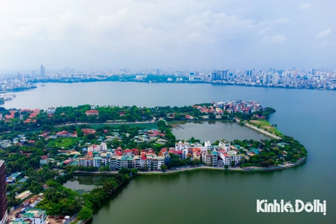
| Hanoi has transformed significantly following a rapid urbanization process. Photo: Thuy Chi/The Hanoi Times |
.jpg)
Necessity to revise existing planning
In 2011, the Prime Minister approved the general plan for capital construction until 2030, with a vision to 2050 (QHC2011). This plan designates the expanded inner-city area, extending from Ring Road No.2 to Nhue River, encompassing districts such as Cau Giay, Thanh Xuan, Hoang Mai, Nam Tu Liem, Bac Tu Liem, and Ha Dong, with a maximum population target of approximately 0.9 million people.
The primary purpose of this region is to decongest the historic inner-city area through existing and new developments. This includes the establishment of new urban centers and areas.
To implement the approved QHC2011 plan, the Hanoi People's Committee has approved four urban zoning planning projects: H2-1 (Tay Ho, Cau Giay, Bac Tu Liem), H2-2 (Cau Giay, Nam Tu Liem), H2-3 (Cau Giay, Thanh Xuan), and H2-4 (Hoang Mai, Thanh Tri, Ha Dong).
Luu Quang Huy, the Director of the Hanoi Urban Planning Institute, mentioned that the approved urban zoning plans in the expanded inner-city area generally align with the nature and functions outlined in QHC2011.
However, the process of materializing QHC2011 still reveals some deficiencies and drawbacks. Notably, this area has recently undergone significant changes in construction space, marked by the formation of new urban areas and increased construction density in existing urban areas.
"Although the infrastructure network has rapidly developed, it has struggled to keep up with population growth, leading to issues like traffic congestion, flooding, and environmental pollution," said Huy.
A critical problem, he added, is the inadequate provision of social infrastructure systems, such as schools, hospitals, parks, and parking lots. This deficiency stems from the delay in the process of relocation of industrial, educational, and healthcare facilities to free up land for community use.
In addition, the implementation of a green park system in areas like Dam Hong, Ha Dinh, and Dinh Cong, following the QHC2011 orientation, faces feasibility issues due to residential areas that have existed for many years.
Moreover, the rapid urbanization rate has significantly impacted the population growth of the expanded metropolitan area. While the regional population target set by QHC2011 essentially meets existing residential areas and some approved investment projects, it poses difficulties in developing new urban areas and housing projects to stay in line with QHC2011's objectives.
"Districts within the expanded inner-city area still have pressing needs for economic, social, and urban development that require prompt resolution, but they encounter limitations in terms of maximum population number set in the plan, resulting in numerous implementation challenges and issues," said Huy.
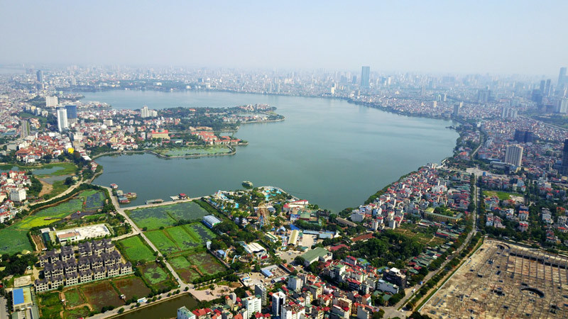
| West Lake from above. West Lake is set to be home to the administrative center of ministries and Government agencies. Photo: Pham Hung/The Hanoi Times |
New proposed orientations
Highlighting the discrepancies between planning requirements, orientations, and the actual circumstances, it becomes evident that various factors impact the management of urban administration and architectural planning in each locality within the region.
Consequently, the research unit proposes changes in the Capital's General Planning to 2045, with a vision to 2065.
Architect Le Hoang Phuong from the Vietnam Institute for Urban and Rural Planning – one of the consulting units for the 2045 planning project, noted the first task is to conduct an initial review and reallocation of scale in response to population growth within the expanded inner-city area.
"The objective is to align with the direction of reducing pressure on infrastructure in historic inner-city areas," he said.
Simultaneously, policy mechanisms are recommended to address challenges in relocating small educational institutions, medical facilities causing pollution, and industrial facilities not conforming to the planning.
These measures include ensuring the handover of land to the city after relocation for the development of projects serving regional public benefits. Additionally, a meticulous review of the legal status in areas entangled in recent lawsuits due to planning issues is emphasized, Phuong noted.
Concerning the development orientation of urban space and infrastructure, Phuong expects to form an administrative center for ministries and branches in the West Lake and Me Tri-My Dinh areas. This involves the construction of high-rise spaces to create a modern urban image along Ring Road No.3 and radial axes within the inner-city area.
The plan encourages the adaptation of existing and future urban areas to new, concentrated, modern, high-rise urban spaces with comprehensive and synchronized urban services. The urban space orientation in the vicinity of the urban railway station area adheres to the Transit-Oriented Development (TOD) model with a radius of approximately 500 - 1,000 meters.
Additionally, the proposal includes the establishment of an international and regionally significant center at West Lake, encompassing cultural, commercial, service, financial, tourism, banking, entertainment, and park functions.This is complemented by the completion of a sports center in My Dinh-Me Tri, along with the development of high-quality service centers and the enhancement of open spaces, trees, and water surfaces. The plan also calls for the construction of diverse housing areas to meet the varying housing needs of the population.
Phuong added that other recommendations involve the reconstruction of old apartment buildings with a focus on high-rise development, reduced construction density, and attention to social and technical infrastructure.
Preservation of historical monuments and urban architecture is also emphasized.
Meanwhile, Phuong noted the plan suggests utilizing land along the Nhue and To Lich Rivers to create a continuous water surface green park system connected to a chain of complete green parks linked to the Red River ecological green system. Furthermore, it proposes the creation of green spaces associated with a drainage ditch system connecting the Nhue River to West Lake and the Nhue River to the To Lich River.
In addition, the proposal underscores the need to promote investment in the transportation system, prioritizing the development of public transportation. It recommends enhancing traffic conditions in some sections along Ring Roads No.2, 3, National Highway 6, and National Highway 1 from Ring Road No.2 to Ring Road No.4.
The plan also suggests constructing an underground Metro system from Ring Road No.2 onwards and adding underground parking systems in gardens and under high-rise buildings. Finally, the proposal calls for the creation of walking space axes connecting central areas.
| In the upcoming period, the expanded inner-city area will concentrate on vital strategies for urban reconstruction, emphasizing the enhancement of technical infrastructure and the expansion of social infrastructure. This will be achieved by reassessing the land fund through land acquisition and relocation of facilities to areas outside the city. Special attention will be given to evaluating various undeveloped projects to recalibrate the land fund, ensuring the minimum required public land for urban and regional projects. Furthermore, specific standards regarding building height and construction density are recommended to be applied, thereby providing prerequisites for the establishment of schools, healthcare facilities, cultural spaces, and green parks essential for urban development, said architect Le Hoang Phuong. |